

Overhead Road Condition Assessment - ORCA
ORCA SYSTEM
-
Speed of Tech
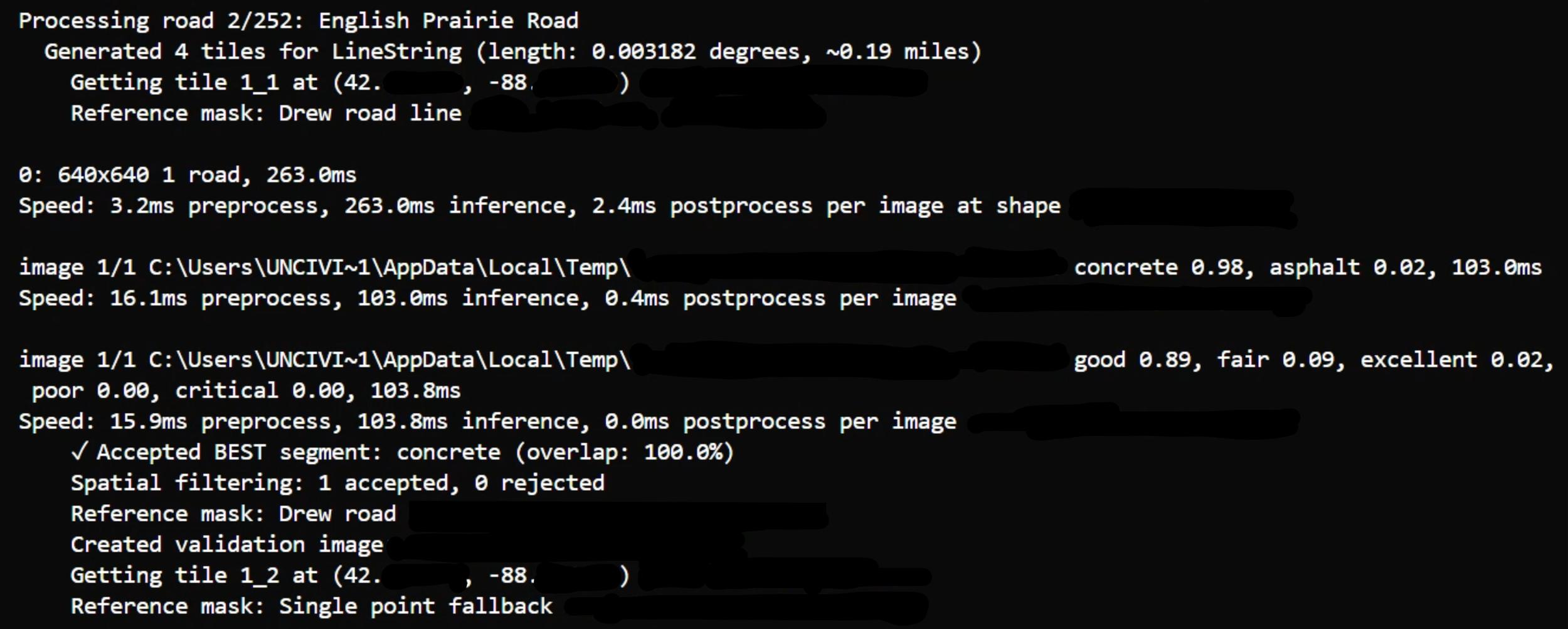
The Overhead Roadway Condition Assessment (ORCA) helps communities respond and prepare quickly, keeping assessments fast and accurate. We leverage the technology to get you quality information and results FAST for regardless of community size.
Our streamline software allows for hundreds of miles to be processed and assessed quickly and reliably.
-

Industry Knowledge
The Overhead Roadway Condition Assessment (ORCA) system is helping communities plan for the future while deploying industry knowledge for use anywhere. Why use just one expert when you can take advantage of the aggregate expertise of the industry?
Our systems are trained on hundreds of roads, with thousands of assessments for each material type so you can be confident our system knows what it is looking at and knows when it doesn’t.
Take advantage for your community today.
-

Engineering Partner
Overhead Roadway Condition Assessment (ORCA) is the first step in a long path of automating data acquisition, verification, and tools that we plan to build to partner with engineers and public works teams. The system helps cut down on manual drive time, while providing input from the local expert.
Receive industry standard file types like shapefiles, or a finished map of the data. Our team can prepare custom data delivery options if needed too!
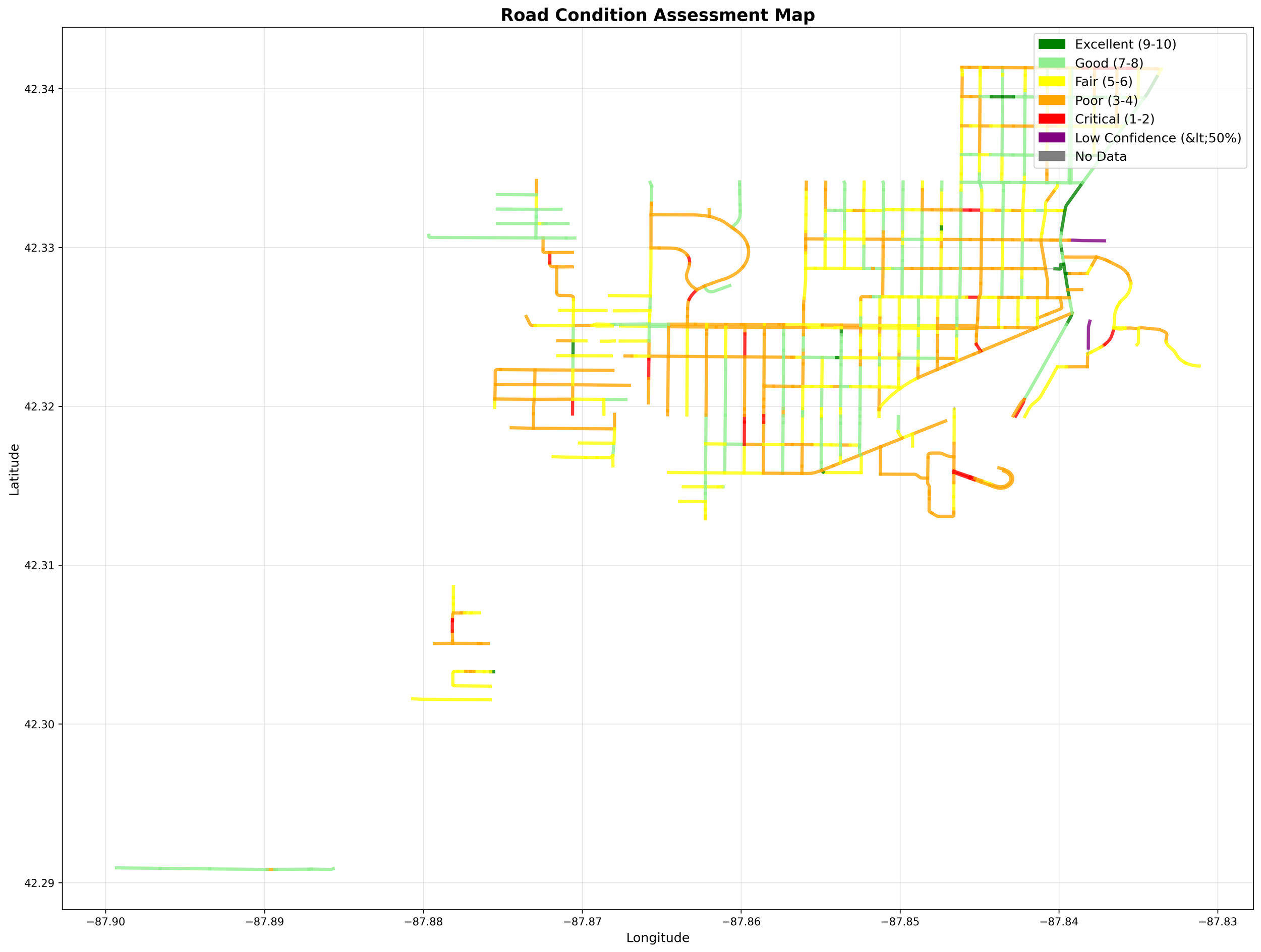
Video of the road condition assessments being displayed. This City’s 50 miles of road took less than 24-hrs to perform the assessment, though is sped up in the video for demonstration purposes.
The Speed of Tech
Convert days and weeks of work, into minutes and hours. ORCA’s cutting edge workflow uses clear imagery and computational power to rapidly, acquire, review, and assess road condition.
This saves the municipalities and consultants hours of driving and hundreds to thousands in expenses. Allowing the teams to focus on more complex and critical tasks.

Industry Knowledge
Doctors go to school, body builders go to the gym, and our AI models went through rigorous model training. Using industry standard processes we trained, tested, and documented the condition assessment for roadways for the field.
These assessments may differ slightly between reviewers, but at scale, a consistent opinion emerges and allows the municipalities and engineering firms to take advantage of the years of training and experience from a number of trainers and sources.
Engineering Partner
Where we are headed, you don’t need cars.
Are you a State or County DOT responsible for 100s of miles? We can provide fast and affordable condition assessments that will allow you to better plan and deploy taxpayer capital to improve the roads and allocate to constituent project needs. No more waiting for weeks to receive the data.
Did your region get aerial imagery taken recently? Even better! We can use local high quality imagery (NAIP, etc), because your price at volume gets better! It may take an extra day or so for pre-processing/preparing the image data, you can use the data you already paid for.
Have a remote customer, but still want to design the resurfacing program, get estimated quantities, and expand your reach? The assessment is the first tool in the tool belt and we have many more in development to help with that problem.
The Working Relationship
What we need from you:
If you have a shapefile of your roads
Great! We will upload that to the software and get a copy of the assessment back.
If you do not have shapefile of your roads No worries, but we still need to know assessment limits. We will use one of our subconsultants to generate a shapefile off of an existing dataset (and its yours to keep after). We can’t commit to the 24-hr turn around time in that case, but it should be within 7 working days. We are working towards an interactive map so you can draw a box to select roads.
What we provide under standard rates:
Condition Assessment Data .csv
Interactive web map file - can be loaded and viewed on any browser
ESRI Shapefile format
DWG format
.jpg of the condition assessment
Need to delegate more or need customizations? We are glad to do that for additional fee and time.